UNIFIED DEVELOPMENT ORDINANCE
ZONING DISTRICS
Section 11-2-1. Zoning Districts, Generally.
(a)
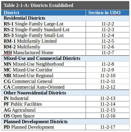
Zoning Districts Established. Zoning districts are established as shown in Table 2-1-A. Zoning districts are established by the City's adoption of the official Zoning District Map pursuant to Subsection 11-2-1(b).
(b)
Official Zoning District Map.
(1)
Generally. The boundaries of zoning districts are shown on the Zoning District Map attached to and incorporated in this Code. Such map may be examined during office hours at the office of the City Clerk.
(2)
Zoning District Boundaries.
(A)
Unless otherwise stated in this article, the zoning district boundaries are the centerlines of the streets, roads, highways, alleys, and channelized waterways or extensions of such centerlines.
(B)
In the event that a zoning district boundary is unclear or is disputed, the Director shall determine the location of the zoning district boundary. An appeal of such determination shall be heard by the Board of Adjustment pursuant to Subsection 11-6-7(d), Appeal.
(C)
Unless otherwise stated in this chapter, changes to the boundaries of any zoning district require an amendment pursuant to the rezoning procedures in Subsection 11-6-4(a), Rezoning.
(c)
Organization of this Article.
(1)
Base Zoning Districts.
(A)
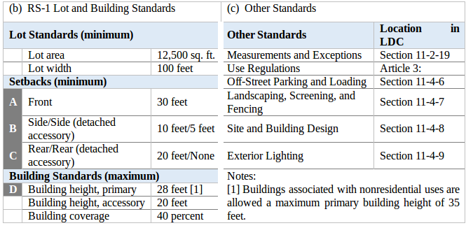
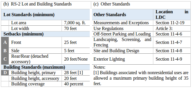
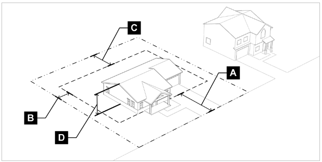
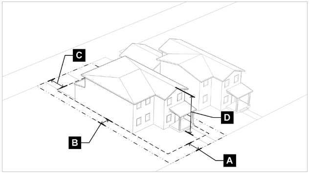
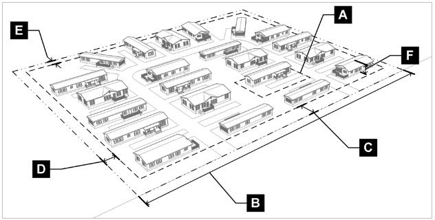
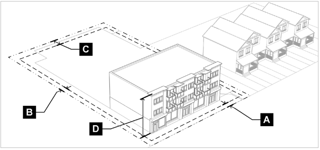
Content. Sections 11-2-2 through 11-2-16 of this article follow a common structure and describe the purpose and intended character of each zoning district, followed by the lot and building standards that apply to that district, and any district-specific development standards. Additional standards that may apply to base zoning districts are included with the lot and building standards under "other standards." Those "other standards" are included for cross-reference and convenience, and do not represent all standards that may be required for a particular development or application.
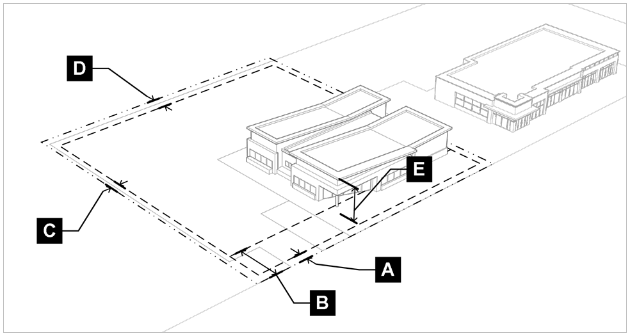
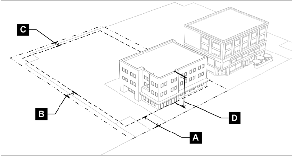
(B)
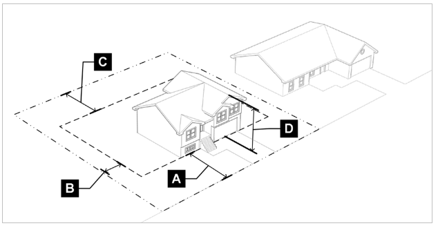
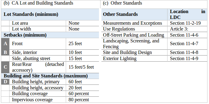
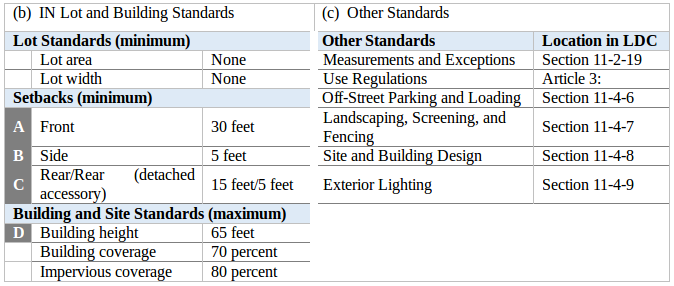
Graphics. For each base zoning district, an illustration is provided that demonstrates visually how the district's lot and building standards apply to lots, buildings, and structures. The illustrations are intended to show the general character of the district but do not show specific locations or buildings. The main purpose of the graphic is to illustrate the lot and building standards and the graphics do not necessarily reflect all standards that may apply to a development. If an illustration is inconsistent with the respective table of lot and building standards, the standards in the table shall govern.
(2)
Planned Development (PD) District. The PD district in Section 11-2-17 is established for individually negotiated developments that cannot otherwise meet the intent or standards of a base zoning district within the City.
(3)
Summary Tables of Lot and Building Standards. Section 11-2-18 summarizes the lot and building standards across the various zoning districts for comparison purposes.
(4)
Measurements and Exceptions. Section 11-2-19 provides uniform methods of measurement for interpretation of the lot and building standards in this UDO.
[Source: Ord. 1966, 2019; 1782, 2019]
Section 11-2-2. RS-1 Single-Family Large-Lot.
(a)
Purpose. The RS-1 district is intended to provide large-lot suburban neighborhoods that accommodate single-family detached homes. The RS-1 district is intended to promote a low-density residential environment and prohibit most commercial activities other than allowed home occupations and limited community and educational uses.
[Source: Ord. 1966, 2019; 1872, 2019; 1821, 2021]
Section 11-2-3. RS-2 Single-Family Standard-Lot.
(a)
Purpose. The RS-2 district is intended to provide standard-sized lots in suburban neighborhoods that accommodate single-family detached homes. The RS-2 district is intended to promote a low-density residential environment and prohibit most commercial activities other than allowed home occupations and limited community and educational uses.
[Source: Ord. 1966, 2019; 1872, 2019; 1821, 2021]
Section 11-2-4. RS-3 Single-Family Small-Lot.
(a)
Purpose. The RS-3 district is intended to provide small residential lots with single-family uses in both urban and suburban neighborhoods. The RS-3 district is intended to promote medium- to high-density residential development but prohibit most commercial activities other than allowed home occupations and limited community and educational uses.
[Source: Ord. 1966, 2019; 1821, 2021]
Section 11-2-5. RM-1 Multifamily Limited.
(a)
Purpose. The RM-1 district is intended to provide housing at mixed densities including primarily single-family attached uses with limited small-scale multifamily uses. The RM-1 district may serve as a transition between higher density and/or intensity districts and lower density residential districts. The RM-1 district is intended to prohibit most commercial uses other than allowed home occupations and limited community and educational uses.
[Source: Ord. 1966, 2019; 1821, 2021]
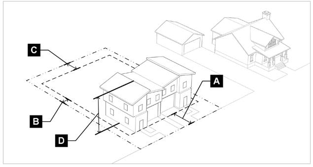
Section 11-2-6. RM-2 Multifamily.
(a)
Purpose. The RM-2 district is intended to provide housing at varied densities including attached single-family and multifamily uses. The RM-2 district also may include community, educational, and limited supportive uses. The RM-2 district may serve as a transition between higher intensity commercial and mixed-use districts and lower density residential districts.
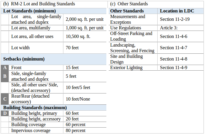
[Source: Ord. 1966, 2019; 1821, 2021]
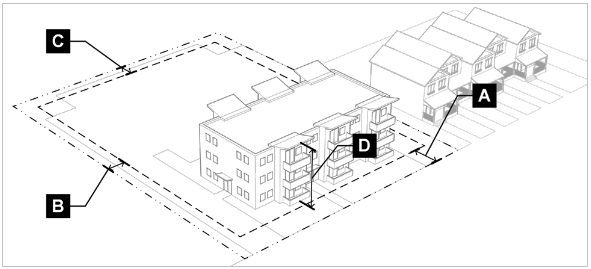
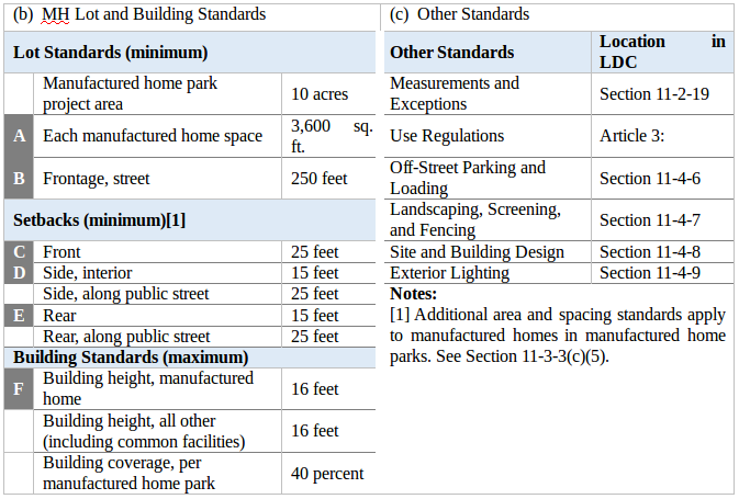
Section 11-2-7. MH Manufactured Home.
(a)
Purpose. The MH district is intended to accommodate medium-density single-family housing and manufactured housing. The MH may also include community and educational uses. The MH district may serve as a transition between higher intensity commercial and mixed-use districts and other medium-density residential districts.
[Source: Ord. 1966, 2019]
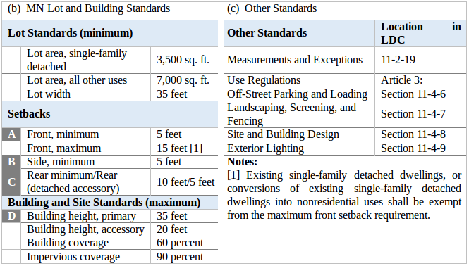
Section 11-2-8. MN Mixed-Use Neighborhood.
(a)
Purpose. The MN district is intended to accommodate primarily residential uses with limited community and commercial uses with appropriate accessory uses. Residential uses in the MN district are intended to offer a diversity of housing opportunities at varied densities. Commercial uses in the MN district should typically be limited to those providing retail and services to the convenience of the neighborhood. Mixed-use development in the MN district is intended to be walkable, have an active streetscape, and be compatible with surrounding residential uses.
[Source: Ord. 1966, 2019; 1821, 2021]
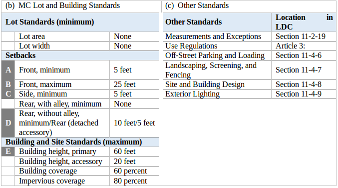
Section 11-2-9. MC Mixed-Use Corridor.
(a)
Purpose. The MC district is intended to accommodate mixed-use development with walkable active streetscapes. Uses in the MC district are typically lighter-intensity commercial with limited auto-oriented uses that are compatible with surrounding residential neighborhoods. Residential uses in the MC district are intended to offer a diversity of attached housing types at varying densities.
[Source: Ord. 1966, 2019]
Section 11-2-10. MR Mixed-Use Regional.
(a)
Purpose. The MR district is intended to accommodate areas for large-scale mixed-use development and redevelopment that is intended to serve the City and the region. The MR district requires adequate automobile access and circulation while providing pedestrian-friendly development and good access to public amenities and public transportation. Uses in the MR district are typically regional-scale employment, commercial activities and services, with limited higher-density residential uses.
[Source: Ord. 1966, 2019]
Section 11-2-11. CG Commercial General.
(a)
Purpose. The CG district is intended to accommodate a wide variety of commercial uses throughout the City. Uses in the CG district often include auto-oriented uses but the district is intended to promote pedestrian-friendly development where appropriate. Typical uses in the CG district include retail, office, services, small-scale business parks, and cultural and community uses that serve both Northglenn and surrounding market areas.
[Source: Ord. 1966, 2019]
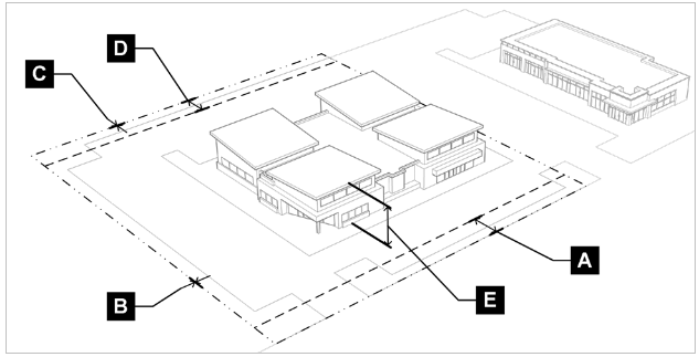
Section 11-2-12. CA Commercial Auto-Oriented.
(a)
Purpose. The CA district is intended to accommodate a wide variety of commercial and limited light industrial uses throughout the City. Uses in the CA district typically include auto-oriented uses that require multiple access points and larger off-street parking and loading areas than are necessary in other commercial and mixed-use areas. Typical supporting uses in the CA district include retail, office, and service uses.
[Source: Ord. 1966, 2019]
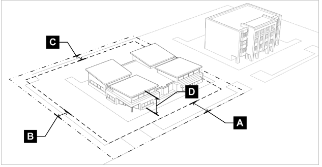
Section 11-2-13. IN Industrial.
(a)
Purpose. The IN district is intended to accommodate industrial and/or heavy commercial uses such as warehousing, service, storage, wholesale and distribution services, research and development, and limited processing and manufacturing uses mostly contained within enclosed buildings and with limited impacts to surrounding neighborhoods. The IN district requires adequate automobile access and sometimes rail access and should provide adequate buffering between residential and other lower-intensity districts.
[Source: Ord. 1966, 2019]
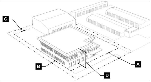
Section 11-2-14. PF Public Facilities.
(a)
Purpose. The PF district is intended to accommodate and preserve areas for public, quasi-public, and limited private facilities and uses. Uses in the PF district typically include essential City services and activities, with limited supporting uses and activities. The PF district is intended to incorporate flexibility to allow varying operational and site characteristics associated with essential City or community services.
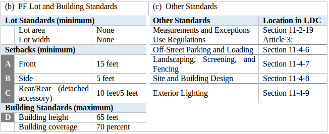
[Source: Ord. 1966, 2019]
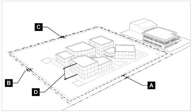
Section 11-2-15. AG Agricultural.
(a)
Purpose. The AG district is intended to preserve areas in the City for agricultural, rural residential, open space, and other related uses. The AG district is characterized by open areas of range land, large planted areas, and natural undisturbed areas that are mostly rural. The AG district may also be used to accommodate newly annexed property until such time as another appropriate zoning district is designated.
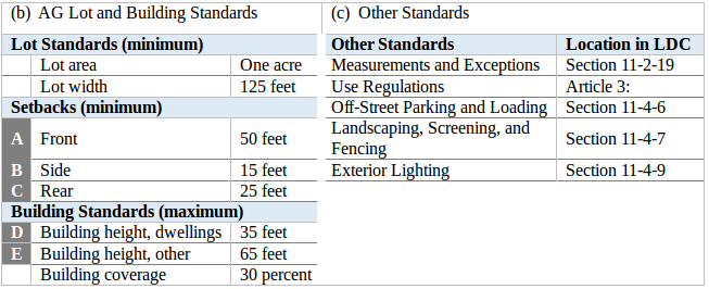
[Source: Ord. 1966, 2019]
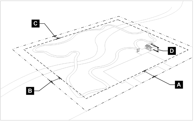
Section 11-2-16. OS Open Space.
(a)
Purpose. The OS district is intended to provide for recreational uses and natural areas and to protect those lands from being used for purposes other than recreational and natural areas. The OS district is intended to accommodate public and quasi-public open space, parks, and compatible accessory uses and structures.
[Source: Ord. 1966, 2019]
Section 11-2-17. PD Planned Development.
(a)
Purpose. The PD district is intended to:
(1)
Achieve greater flexibility than allowed by the strict application of this UDO in exchange for more creative and imaginative designs with a higher level of amenities and public benefit than otherwise possible under the base zoning districts;
(2)
To ensure compatibility between residential and nonresidential or mixed-use areas and to minimize impacts to those areas from more intensive uses; and
(3)
To allow various combinations of land uses in multi-phased developments.
(b)
Establishing a Planned Development District. Planned Development districts are established by the City's approval of a rezoning pursuant to Section 11-6-4(b). The rezoning to PD procedure shall not be used when a special use permit, variance, administrative adjustment, or rezoning to another base zoning district could achieve a similar result.
(c)
Planned Development Standards. The standards for development within a PD district are established by an approved PD plan with adoption of a rezoning to a PD district.
[Source: Ord. 1966, 2019]
Section 11-2-17.5. MX Mixed-Use Overlay District.
(a)
Purpose. The Mixed-Use Overlay District (MX) is established in order to achieve, among others, the following purposes:
(1)
Provide an opportunity for a mix of land uses consistent with the City's Unified Development Ordinance, while protecting the public health, safety, and general welfare;
(2)
Provide for and encourage a balanced, compatible mix of uses, rather than a separation of uses, in a pedestrian-friendly environment;
(3)
Establish development standards that allow for flexibility while protecting adjacent property from undue adverse impacts;
(4)
Promote investment in locations where investment is otherwise impeded due to small lot sizes, inefficient shape of the property, the existing underutilized development, or existing "strip" development that impedes pedestrian friendliness, or development that exhibits functional obsolescence; and
(5)
Create vibrant public spaces through the use of pedestrian-oriented design principles and enhanced aesthetic design of buildings and structures.
(b)
Establishment. A Mixed-Use Overlay District shall be established in accordance with 11-6-4(a). The boundaries of the Mixed-Use Overlay District shall be indicated on the Official Zoning Map and shall be officially denoted as MX. For the purposes of zoning, development, and use regulations, the Mixed-Use Overlay District shall be regulated under the standards of the related mixed-use zone as established in Article 2.
(c)
Procedures for Development Approval.
(1)
Generally. Applicants wishing to pursue development in accordance with the Mixed-Use Overlay District parameters on land that has been designated MX may do so via the application process delineated in Article 6: Administration and Procedures. Development Review Procedures applicable to a Mixed-Use Overlay District Development fall under Major Site Plan requirements (Section 11-6-5(a)(3)) unless otherwise determined by the City.
(2)
Additional Provisions. Any existing provisions that are not covered by this section shall be governed by the respective provisions and requirements found elsewhere in the Unified Development Ordinance, unless modified by the Mixed-Use Overlay District Development Permit Application as provided for below.
(d)
Permitted Uses.
(1)
Generally. Unless regulated in this section or modified as provided for in Section 11-2-17.5(c)(3), a Mixed-Use Overlay District Development shall comply with the following regulations, as is pertinent:
Article 2: Zoning Districts, Section 8: MN Mixed-Use Neighborhood;
Article 2: Zoning Districts, Section 9: MC Mixed-Use Corridor;
Article 2: Zoning Districts, Section 10: MR Mixed-Use Regional; and
Article 3: Use Regulations
(2)
Additional Considerations. In determining the appropriateness of each proposed use, the City shall determine that the plan satisfies one or more of the following:
That the proposed uses will fulfill the purpose statements expressed in Section 11-2-17.5(a);
That the proposed use(s) contributes to the pedestrian atmosphere desired by the City;
That the proposed use(s) promotes a vital, mixed-use environment;
That the proposed use(s) is compatible with any other and will not unduly impact the public health, safety, and general welfare;
That the proposed use(s) will further the creation of a Mixed-Use development that can be used by residents of the Mixed-Use Development, users of other establishments in the Mixed-Use Development as well as adjacent parcels, if applicable; or
That the proposed uses will include the necessary diversity of uses needed to prevent the segregation of uses and to ensure a dynamic developed site.
(e)
Development Criteria.
(1)
Generally. Unless regulated in this section or modified as provided for in Section 11-3-2(c)(3), a Mixed-Use Overlay Development shall comply with the appropriate regulations:
(A)
Article 2: Zoning Districts, Section 8: MN Mixed-Use Neighborhood;
(B)
Article 2: Zoning Districts, Section 9: MC Mixed-Use Corridor; and
(C)
Article 2: Zoning Districts, Section 10: MR Mixed-Use Regional.
(4)
Additional Standards Considered. The following standards will be considered in a Mixed-Use Overlay District Development Permit Application in addition to the previously delineated standards:
Buildings, structures, and parking areas should be designed and located within the Mixed-Use Development in ways that conserve unique natural, historic, or cultural features;
The physical relationship of buildings and other site improvements to one another and to the surrounding public streets, as created by building size, mass, height, shape, and setback, shall result in a harmonious development within the Mixed-Use Development and adjacent to it; and
The bulk of buildings within the proposed development shall be compatible with the surrounding development and sufficiently buffered from the surrounding development, when integration with the surrounding development is not desired, to mitigate any undue adverse impact(s).
(f)
Affordable and Senior Housing Incentives. The Director may approve incentives for those providing dwelling units that are restricted for purchase or occupancy at below-market rate levels, or dwelling units that are restricted for purchase or occupancy by persons 55 years of age or older. The incentives listed in 11-2-17.5(f)(2) may be provided in addition to the parking reductions noted in subsection 11-4-6(g)(4).
(5)
Eligibility Standards.
Applicants electing to provide income restricted units must provide the number of units at the income-restricted levels in accordance with the options set forth below:

(B)
Applicants electing to provide dwelling units restricted for purchase or occupancy by persons 55 years of age or older must make at least 75% of all units in the development restricted by age.
(15)
Incentives.
(A)
Expedited Review.
(i)
Review per submittal will be no more than three weeks by all City departments.
(ii)
Application submittals must be complete and include all requested items for the three-week review period to begin.
(iii)
Review timelines may not be expedited for any outside agency.
(B)
Fee Reduction.
(i)
All City required fees associated with development may be reduced in accordance with the table below.

(C)
Reduction of Building and Design Standards.
(i)
Setback requirements pursuant to Sections 11-2-8: MN Mixed-Use Neighborhood, 11-2-9: MC Mixed-Use Corridor, and 11-2-8: MR Mixed-Use Regional shall be waived.
(ii)
Buildings shall not extend more than 50 continuous feet without incorporating at least three of the five Massing Reduction Elements in subsections 11-4-8(e)(4)(C)(i-v) below for each 50-foot segment.
[Source: Ord. 1854, 2023]
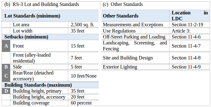
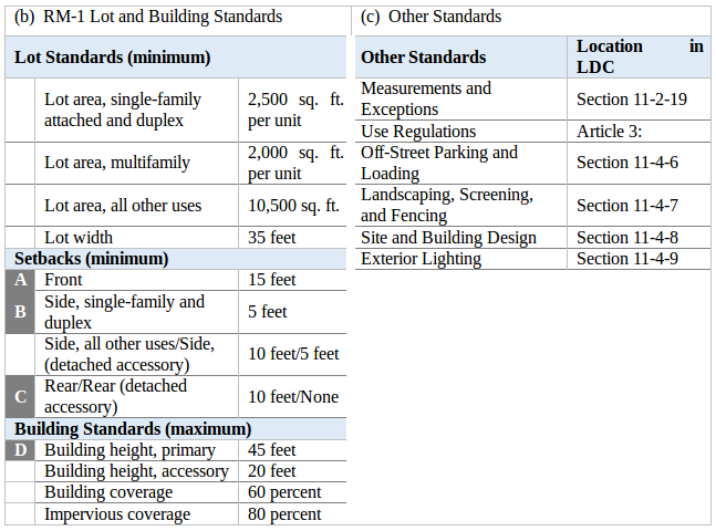
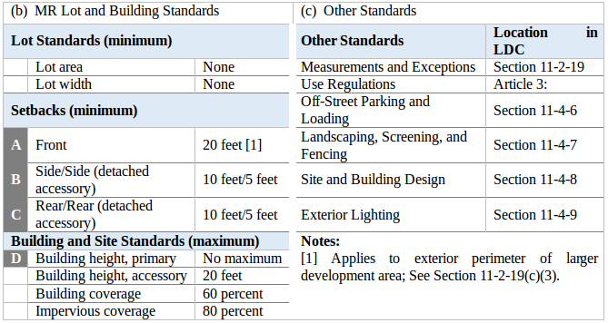
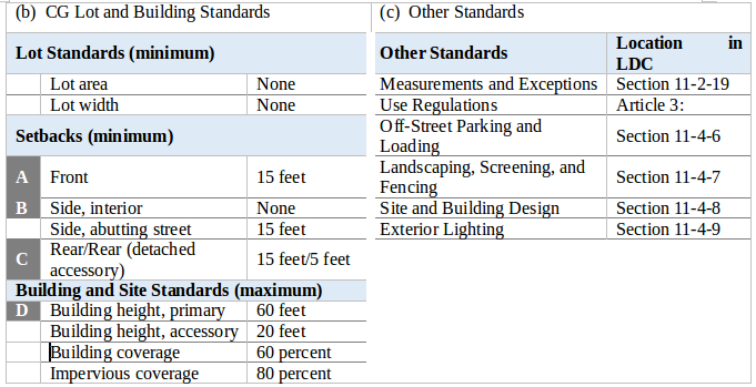
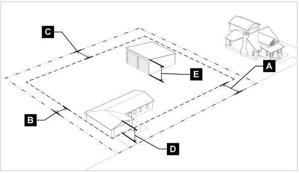
Section 11-2-18. Summary Tables of Lot and Building Standards.
(a)
Residential Zoning Districts.
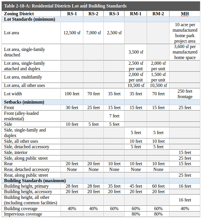
(b)
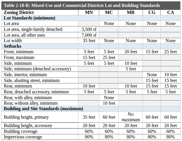
(c)
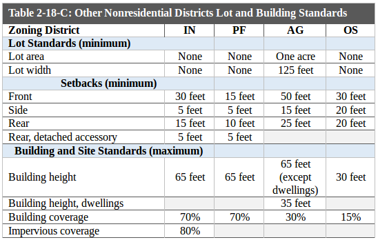
[Source: Ord. 1966, 2019; 1872, 2019]
Section 11-2-19. Measurements and Exceptions.
(a)
Purpose. The purpose of this section is to provide uniform methods of measurement for interpretation and enforcement of the lot and building standards in this UDO.
(b)
Lot and Site Requirements.
(1)
Minimum Lot Dimensions.
(A)
Any lot that is created, developed, used, or occupied shall meet the minimum lot area and width requirements established in this Article for the zoning district in which it is located unless otherwise established in this UDO for specific uses. New lots shall also meet the development standards in Subsection 11-5-3(d), Block and Lot Design.
(B)
No area required to meet the lot and building requirements of this UDO may be sold or leased away from such lot or building.
(2)
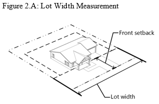
Lot Width Measurement. Lot width shall be measured at the front setback line. In districts with a maximum front setback, the lot width shall be measured at the maximum front setback line. See Figure 2.A below.
(3)
Number of Principal Buildings or Uses per Lot. Where a lot or tract is used for multifamily and nonresidential uses more than one primary building may be located on such lot or tract provided such buildings comply with the development standards in this UDO.
(c)
Setbacks.
(1)
Measurement.
(A)
Setbacks referred to in this UDO shall be measured as stated in the definitions in Article 7 under the term "setback."
(B)
No part of a setback area required for any building shall be included as a setback area for a building on a separate lot or tract.
(C)
Multifamily dwellings on one lot shall be construed as one structure for purpose of measuring setbacks.
(2)
Zero Lot Line Configurations.
(A)
Unless otherwise stated in this UDO, for purposes of calculating setbacks for side-by-side (zero lot line) configurations of nonresidential, duplexes, single-family attached dwellings, and multifamily dwellings, only those units and/or dwelling units that do not share a common wall with an adjacent unit and/or dwelling unit are required to comply with the side setback for the applicable zoning district.
(B)
For nonresidential development projects on sites five acres or greater, interior side setbacks may be reduced with approval by the Director pursuant to the Administrative Adjustment procedure in Subsection 11-6-7(b).
(3)
Front Setbacks in the MR District. In the MR district, front setbacks shall only apply to the exterior development area along the perimeter of the larger development site. Individual building pads shall not be subject to front setback requirements.
(4)
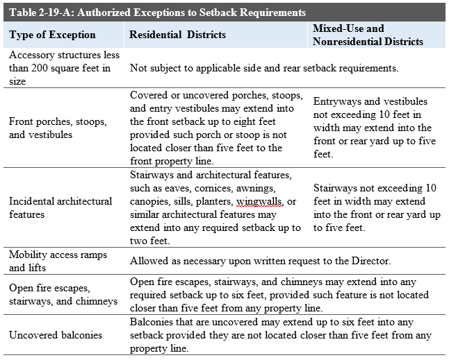
Exceptions to Setback Requirements. Every part of a required setback shall be unobstructed from ground level to the sky except as follows:
(A)
Setback restrictions do not apply to slabs, uncovered patios, walks, fences, landscaping improvements such as hedges, or freestanding walls. Each of those features shall comply with other applicable sections of this UDO, including but not limited to development standards and vision clearance area requirements.
(B)
The features and improvements in the table below may encroach into required setbacks. Features not specifically listed in the table below may be considered by the Director to be included with an existing type of exception.
(5)
Accessory Structure Setbacks. Minimum setback requirements for accessory structures 200 square feet or greater in size are as indicated in the zoning district lot and building standards. If a separate requirement for accessory structures is not identified for a zoning district, then the requirement for principal structures in that district shall also apply to accessory structures.
(6)
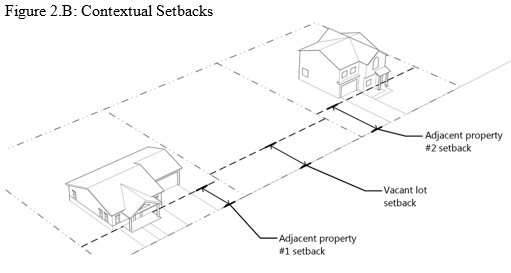
Contextual Setbacks. In any residential district, the minimum front setback on any vacant lot where the front setbacks of adjacent dwellings do not meet the required front setback for that district may be established as the mean average front setback of the two adjacent dwellings. If there is only one adjacent existing dwelling, then the front setback for the vacant lot shall be established as the mean average of the one existing adjacent dwelling and the required front setback for that district. See Figure 2.B below.
(7)
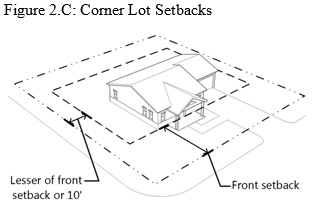
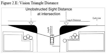
Corner Lots. On corner lots, the front setback shall apply to the street frontage with the primary entrance to the primary building. On the other street frontage where the side yard abuts the street, the setback requirement shall be the lesser of the front setback for the applicable zoning district or 10 feet. See Figure 2.E below.
(8)
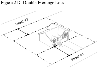
Double-Frontage Lots. In the case of double-frontage lots, front setbacks shall be provided for principal structures on all frontages. For accessory structures on double-frontage lots, the rear setback shall apply to the secondary frontage (Street #2). See Figure 2.D below.
(d)
Vision Triangle Requirements.
(A)
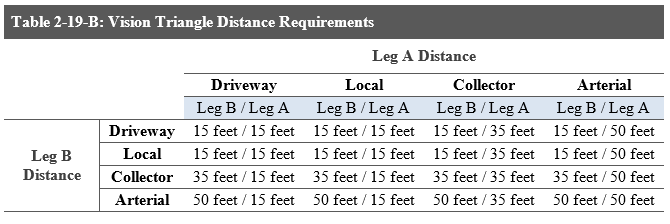
Generally. Vision clearance areas free of obstructions are required where a driveway intersects a public right-of-way or where property abuts the intersection of two public rights-of-way. Unobstructed sight distance shall be provided at all times within the vision clearance area of the property adjacent to the intersection in order to ensure that safe and adequate sight distance is provided for the public use of the right-of-way, pursuant to Table 2-19 B and Figure 2.E below. The Director shall determine the classification of all adjacent roadways used in calculating the required unobstructed sight distance at all intersections. Distances shall be measured along the flowline beginning at the point where Leg A and Leg B intersect.
(B)
Additional Engineering Standards. Additional engineering standards may be applied, at the discretion of the Director, depending on the street and intersections according to general American Association of State Highway and Transportation Officials (AASHTO) standards and any other locally-adopted engineering requirements.
(C)
Exceptions.
(i)
On corner lots, single-family and duplex dwelling uses shall not be subject to the driveway standards in Table 2-19 B.
(ii)
Landscaping may be provided within a vision clearance area provided such landscaping is less than 30 inches in height. Trees may be provided within the vision clearance area provided the lowest branches are more than seven feet above the ground.
(e)
Building Height.
(1)
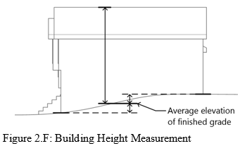
Measurement. Building height shall be measured as the vertical distance measured from the average elevation of the finished grade (the mean elevation of the lowest and highest corners of a structure) to the highest point of the roof. See Figure 2.F below.
(2)
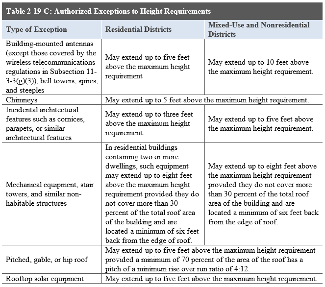
Exceptions to Height Requirements. No building or part of a building shall exceed the maximum building height within any zoning district unless authorized in the table below or elsewhere in this UDO. Features not specifically listed in the table below may be considered with an existing row in that table with Director approval.
(f)
Floor Area and Square Footage.
(1)
All areas within a structure including interior storage areas, closets, living areas, bathrooms, garages, and interior and exterior walls shall be included in the calculation of floor area of a structure. Private outdoor areas for multifamily structures such as porches, balconies, courtyards, plazas, pergolas, gazebos, or similar facilities shall be excluded from this calculation.
(2)
Gross square footage of a structure shall be measured from the outside of the exterior walls and shall include the area of the walls.
(g)
Building and Impervious Coverage.
(1)
Building Coverage Calculation. The area of the lot covered by principal buildings, accessory structures, parking garages, carports, and utility and storage sheds shall be included in the calculation of building coverage in all zoning districts. The Director shall have the authority to determine if additional types of structures count toward building coverage percentages at their discretion.
(2)
Impervious Coverage Calculation. The area of the lot covered by the following shall be included in the calculation of total impervious coverage in all applicable zoning districts:
(A)
Principal buildings;
(B)
Accessory structures, parking garages, carports, and utility and storage sheds;
(C)
Additional types of structures as determined by the Director;
(D)
Porches, stairways, elevated walkways, paved areas, or areas otherwise covered with materials impervious to water; and
(E)
Parking areas and driveways, regardless of surfacing materials unless an alternative pervious paving system is approved by the Director.
[Source: Ord. 1966, 2019; 1782, 2019]